BC Parks Foundation
Naikoon Park
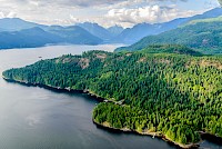
Naikoon Provincial Park is the traditional territory of the Haida Nation, and with almost 7% of Haida Gwaii’s total landmass it covers much of Graham Island’s northeast.
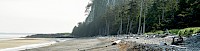
It encompasses a stunning and diverse landscape —the classic west coast temperate rainforest that the name Haida Gwaii brings to mind, but also beautiful bogs and wetlands, rolling sand dunes hiding rare plants, rocky intertidal outrcrops jam-packed with life and 100 km of sandy shorelines. Most of Naikoon is low-lying and flat, which provides a dramatic contrast to the basalt columns that rise above North Beach to form Tow Hill.
Along the northern coastline two ecological reserves are attached to but technically separate from Naikoon: Tow Hill Ecological Reserve, which interestingly, is located a couple of kilometers west of Tow Hill, protects a representative example of the north coast’s ecological diversity, while Rose Spit Ecological Reserve stretches out into the ocean at the most northeastern tip and conserves a sensitive coastal sandy shoreline and dune ecosystem.
Hiking in Naikoon Park
There are a couple of longer hiking trails within Naikoon, however the beauty and diversity of species and habitats found in Naikoon can be encountered even on a short walk or hike in this stunning provincial park or its adjacent ecological reserves.
Tow Hill – The basalt columns that make up Tow Hill rise only 100 m above North Beach, yet the views from multiple lookouts on the way to the top provide some stunning views of the sandy shorelines stretching out east and west as well as the patchwork of forest, bog, and wetland stretching inland. The accessible boardwalk up the hill takes you through forest while protecting the vegetation, while the blowhole boardwalk ends at a rocky outcrop at the base of Tow Hill, providing unobstructed views of the ocean — and even Alaska on a clear day!
White Creek Trail – This trail starts near the mouth of White Creek and winds gently through wetland habitat and old growth cedar and spruce forest, then opens up into a landscape of delicate bogs dotted with stunted shore pines and patches of brightly-coloured peat moss.
Agate Beach & Tow Hill intertidal – Agate Beach is named for the agate stones that hide among cobble in the upper intertidal of this stretch of Naikoon’s northern shoreline. Tow Hill towers above the shoreline just west of Agate Beach, and the lower reaches of Tow Hill’s basalt provides rocky intertidal habitat for an abundance of species vying for space on the rock and in crevices. The proximity of this stretch of shoreline to the Agate Beach campground makes it easy to explore it at a good low tide.
Misty Meadows & East Beach – Trails from the Misty Meadows campground wind through the forest before opening into sandy dunes and the East Beach shoreline, which stretches northward seemingly forever. A bit past the mouth of the Tlell River on East Beach the bow of the Pestula Shipwreck juts out from the sand.
More Parks
“When I get beneath the surface of things, these are not moments of mystery, they are moments of extraordinary clarity. Everything has the energy of its making inside it.
”